Introduction: The Indian Drainage Architecture
The Indian drainage system is a profoundly complex and geographically diverse network shaped by the subcontinent's evolutionary geological history, tectonic activities, and precipitation patterns. This report provides a comprehensive, cross-referenced synthesis of India's eight most critical river basins, drawing on two independently compiled source documents to ensure factual accuracy and completeness across nine exam-critical dimensions: geography, tributaries, dams, lakes, waterfalls, protected areas, river-linking projects, water disputes, and frequently tested facts.
Classification Framework
India's drainage systems are classified into two primary categories based on origin and geomorphological characteristics. The Himalayan rivers (Indus, Ganga, Brahmaputra) are antecedent and perennial, fed by glacial meltwater and monsoon precipitation. They carve deep V-shaped valleys and carry immense sediment loads, forming the world's most extensive alluvial plains and deltas. The Peninsular rivers (Narmada, Godavari, Krishna, Kaveri, Mahanadi) are considerably older, predominantly rain-fed, and flow through broad, shallow, graded valleys indicative of geological maturity, exhibiting significant seasonal discharge fluctuations.
Spatial Orientation
Approximately 77% of India's drainage area is oriented towards the Bay of Bengal, encompassing the Ganga, Brahmaputra, Mahanadi, Godavari, Krishna, and Kaveri. Only about 23% discharges into the Arabian Sea, comprising the Indus system and the rift-valley-bound Narmada and Tapi along with numerous swift streams descending from the Western Ghats. The Ambala ridge forms the critical water divide between the Indus and Ganga systems.
1. The Ganga River System
1.1 Course and Geography
The Ganga originates as the Bhagirathi from the Gangotri Glacier at Gaumukh in Uttarkashi district, Uttarakhand, at approximately 3,892 m altitude. The second headstream, the Alaknanda, rises from the Satopanth Glacier near Badrinath. The two merge at Devprayag, the point where the river officially becomes the Ganga. Five sacred confluences (Panch Prayag) occur along the Alaknanda: Vishnuprayag (Dhauliganga), Nandaprayag (Nandakini), Karnaprayag (Pindar), Rudraprayag (Mandakini), and Devprayag (Bhagirathi).
The Ganga enters the plains at Haridwar, flows through Uttar Pradesh, Bihar, Jharkhand (basin), and West Bengal, covering approximately 2,525 km. Near Farakka in West Bengal, it splits into the Bhagirathi-Hooghly (right, towards Kolkata) and the Padma (left, into Bangladesh). The Ganga-Brahmaputra Delta (Sundarbans) is the world's largest delta and largest mangrove forest, designated as a UNESCO World Heritage Site. The basin covers roughly 8,61,404 sq km (26.4 percent of India's landmass) across 11 states, supporting approximately 43 percent of India's population. It exhibits a dendritic drainage pattern in the plains and an antecedent pattern in the Himalayan section.
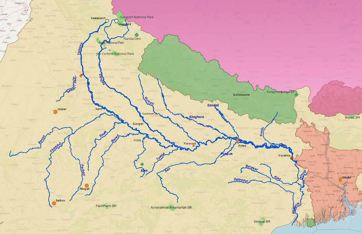
1.2 Tributary Architecture
The Ganga's massive annual discharge results from an extensive network of tributaries descending from the Himalayas (left bank) and the Peninsular plateau (right bank).
1.2.1 Left Bank (Himalayan, Perennial)
1.2.2 Right Bank (Himalayan and Peninsular)
1.3 Hydraulic Infrastructure
1.4 Lakes and Wetlands
- Kanwar Lake (Kabar Taal), Begusarai, Bihar: Asia's largest freshwater oxbow lake; Bihar's first Ramsar Site (2020); formed by Burhi Gandak meandering.
- Haiderpur Wetland, Muzaffarnagar, UP: Ramsar Site; formed by Madhya Ganga Barrage.
- Asan Conservation Reserve, Dehradun: Ramsar Site at Asan-Yamuna confluence.
1.5 Protected Areas
1.6 Ecological Indicators
The Gangetic Dolphin (Platanista gangetica) is India's National Aquatic Animal (2009), classified as IUCN Endangered and listed under Schedule I of the Wildlife Protection Act, 1972. It is practically blind and relies on echolocation. The comprehensive 2021-2023 dolphin survey estimated the Gangetic dolphin population at 6,324 individuals, with the highest concentrations in Uttar Pradesh (2,397) and Bihar (2,220).
1.7 River Linking
The Ken-Betwa Link Project is India's first approved river interlinking project under the National Perspective Plan. It links the surplus Ken River to the deficit Betwa (both Yamuna tributaries) via the Daudhan Dam (77 m) within Panna Tiger Reserve. Cabinet approval came in December 2021 at a cost of Rs. 44,605 crore. The project is ecologically contentious as it threatens to submerge approximately 10 percent of Panna's critical tiger habitat.
2. The Indus River System
2.1 Course and Geography
The Indus originates from a glacier near Bokhar Chu, close to Lake Mansarovar, in the Kailash Mountain Range, Tibet, at approximately 4,164 m. Known as Singi Khamban ("Lion's Mouth") in Tibet, it enters India at Demchok in Ladakh, flows between the Karakoram and Ladakh ranges, carves gorges 4,500-5,200 m deep near Nanga Parbat, then enters Pakistan and drains into the Arabian Sea near Karachi.
Total length: approximately 3,180 km. India derives its very name from the Indus (Sindhu). The river is a trans-Himalayan, antecedent river, older than the Himalayas themselves.
Note on in-India length: Source documents cite both 710 km and 1,114 km. The former refers to the stretch within undisputed Indian territory, while the latter includes the full course through Indian territory.
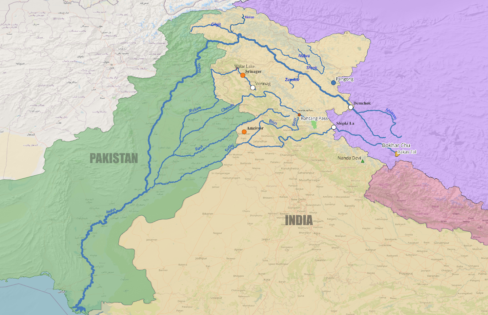
2.2. Left Bank (The Five Punjab Rivers)
2.3 Hydraulic Infrastructure
2.4 Lakes
2.5 Protected Areas
2.6 Water Disputes: The Indus Waters Treaty
The Indus Waters Treaty (1960) allocated the three eastern rivers (Ravi, Beas, Sutlej) to India for unrestricted use, and the three western rivers (Indus, Jhelum, Chenab) to Pakistan with limited non-consumptive Indian use. The treaty features a three-tier dispute resolution mechanism: Permanent Indus Commission, Neutral Expert, and Court of Arbitration.
Critical 2025 Development: India suspended the IWT in April 2025 (the first time in the treaty's 65-year history) following the Pahalgam attack.
2.7 Ecological Indicators
The Indus River Dolphin (Bhulan) is found only in the Indus system. India's known population is critically fragmented, with only three individuals recorded in the Beas River near Harike during the 2021-2023 survey, underscoring the catastrophic impact of flow alterations.
3. The Brahmaputra River System
3.1 Course and Geography
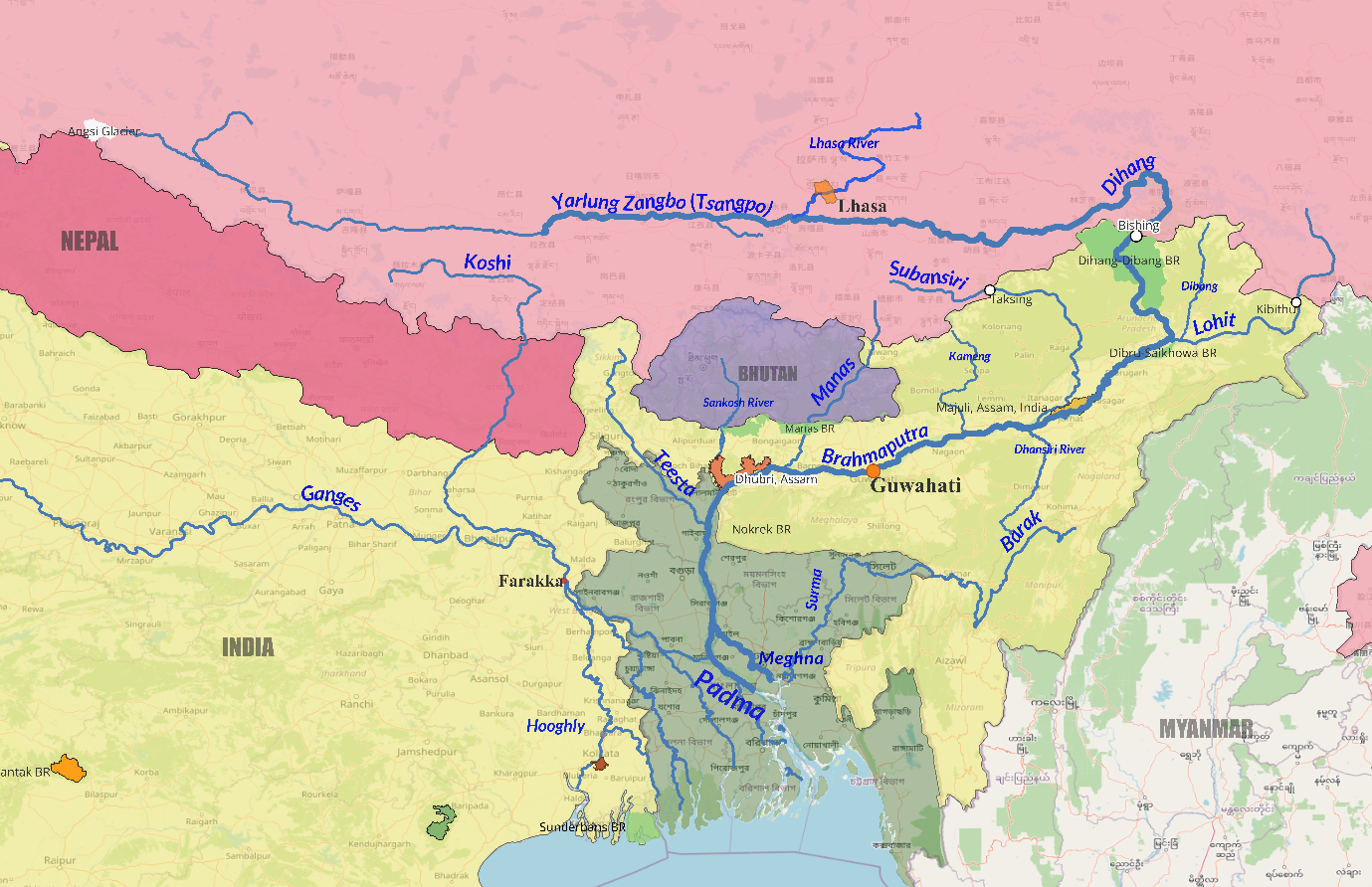
The Brahmaputra originates from the Angsi Glacier near Chemayungdung in Tibet at approximately 5,150-5,300 m. It carries different names across its journey:
- Yarlung Tsangpo (Tibet),
- Siang/Dihang (Arunachal Pradesh),
- Brahmaputra (Assam), and
- Jamuna (Bangladesh).
Near Namcha Barwa (7,756 m), it takes a dramatic U-turn around the eastern syntaxis of the Himalayas, carving the Yarlung Tsangpo Grand Canyon, the world's longest and deepest river canyon. Total length: approximately 2,900 km.
The Brahmaputra exhibits a braided channel pattern in Assam (up to 16-20 km wide in places), carries approximately 590-790 million tonnes of sediment annually, and ranks among the top 5 rivers globally by discharge. It is designated National Waterway 2 (891 km, Sadiya to Dhubri).
3.2 Tributary Architecture
The Brahmaputra flows roughly east-to-west through Assam, so the north bank equals the right bank (Himalayan) and the south bank equals the left bank (Meghalaya/Naga/Patkai hills).
3.3 Hydraulic Infrastructure
3.4 Protected Areas
3.5 Key Geographic Features
- Majuli Island: World's largest inhabited river island; first island designated as a district (2016); UNESCO Tentative List; shrinking from ~1,250 sq km to ~421-880 sq km.
4. The Narmada River System
4.1 Course and Geography
The Narmada originates from Narmada Kund at Amarkantak Plateau, Maikal Hills, Anuppur district, MP, at approximately 1,057 m. It flows westward for 1,312 km, making it India's longest west-flowing river, draining into the Arabian Sea via the Gulf of Khambhat, forming an estuary (not a delta). Its defining feature is that it flows through a rift valley (graben) between the Vindhya Range (north/horst) and Satpura Range (south/horst). This explains both its westward flow and estuary formation: the hard rock terrain in the rift valley means less silt, therefore no delta. The Narmada also forms the traditional boundary between North and South India.
At Amarkantak, the Narmada, Son, and Mahanadi all originate nearby, creating a classic radial drainage pattern. Basin area: 98,796 sq km; MP (82%), Gujarat (12%), Maharashtra (4%), Chhattisgarh (2%). Due to the rift valley confinement, tributaries are short and join at near right angles, creating a classic trellis drainage pattern.
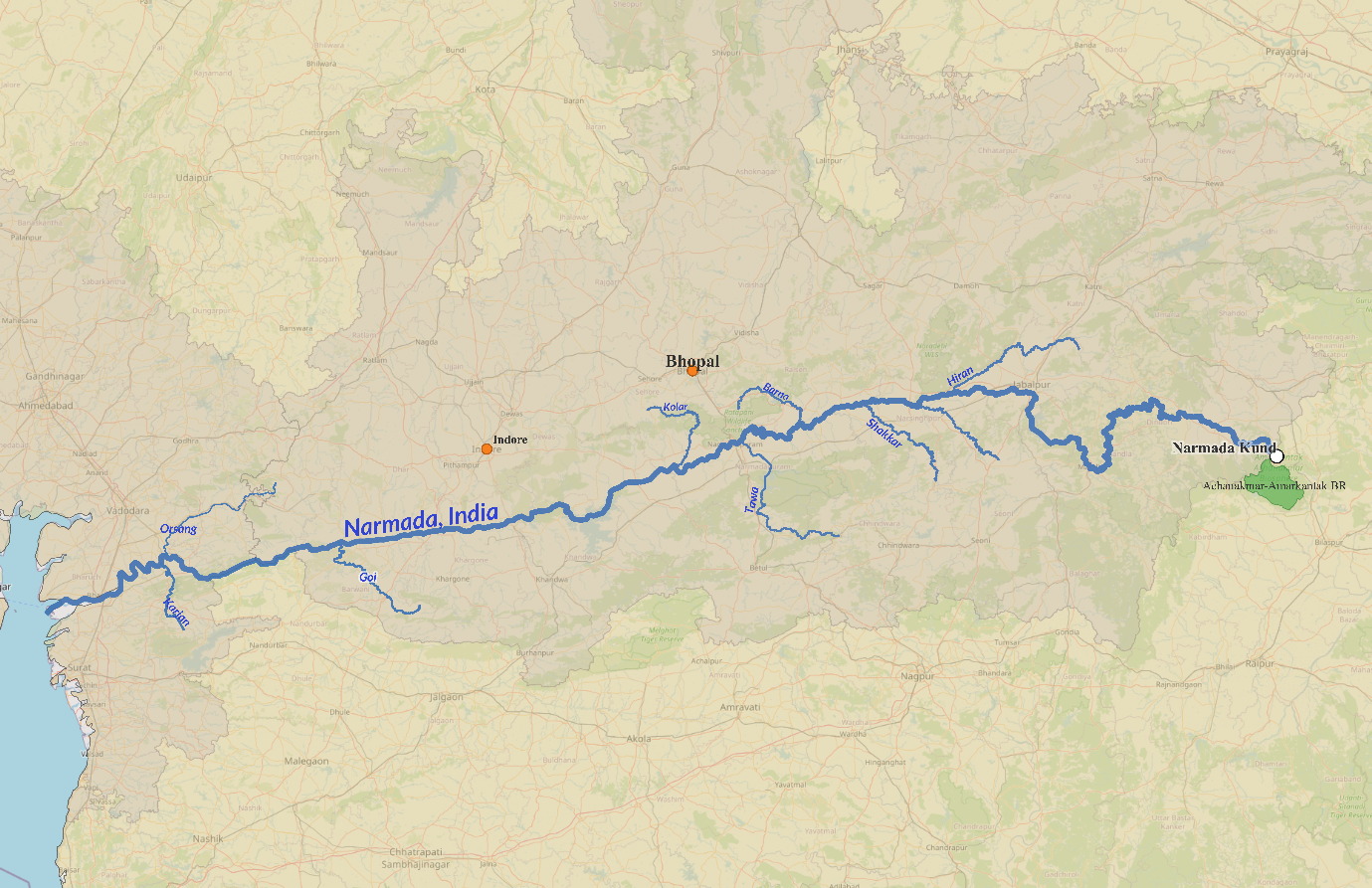
4.2 Tributaries
- Left bank (Satpura Range): Tawa (largest tributary, 172 km), Banjar, Shakkar, Dudhi, Burhner. The Banjar flows near Kanha NP.
- Right bank (Vindhya Range): Hiran, Orsang, Barna, Kolar, Tendoni, Man. Total: 41 tributaries (22 left, 19 right).
4.3 Hydraulic Infrastructure
4.4 Waterfalls and Natural Features
- Dhuandhar Falls at Bhedaghat, Jabalpur: Name means "Fall of Mist/Smoke"; adjacent to the Marble Rocks gorge (8 km of magnesium limestone cliffs, 30-35 m high, river narrows to 18 m). Bhedaghat-Lameta Ghat is on the UNESCO WH Tentative List and is a major dinosaur fossil site (Rajasaurus narmadensis discovered here).
- Kapildhara Falls: Located 8 km from origin at Amarkantak; first waterfall on the river.
4.5 Protected Areas
- Satpura NP/Tiger Reserve: Core of Pachmarhi Biosphere Reserve (UNESCO MAB 2009); bounded by Tawa River. Drained by the Denwa River.
- Bori WLS: India's first reserved forest (1862); part of Pachmarhi BR.
- Kanha NP/TR: Narmada tributaries (Banjar, Sulkum) flow through; barasingha conservation; Jungle Book inspiration.
4.6 River Linking
The Par-Tapi-Narmada Link proposes transferring surplus monsoon water from Western Ghats rivers to water-deficit Saurashtra and Kutch. Seven dams, 395 km canal; cost approximately Rs. 10,211 crore. The project faces intense opposition as it threatens to submerge over 6,000 hectares, displacing 60+ tribal villages.
4.7 Critical Facts
- Narmada Parikrama: Only Indian river with a tradition of complete circumambulation (~2,600-3,500 km walk along both banks).
5. The Godavari River System
5.1 Course and Geography
The Godavari originates at Trimbakeshwar (Brahmagiri Hills) near Nashik, Maharashtra, at approximately 1,067 m, just 80 km from the Arabian Sea, yet flows east 1,465 km to the Bay of Bengal. It is India's second-longest river (after Ganga), the longest peninsular river, and has the largest peninsular river basin at 3,12,812 sq km (roughly 10 percent of India's area). Called "Dakshin Ganga" and "Vridha Ganga" (Old Ganga). Near Rajahmundry, it splits into Gautami Godavari (north) and Vasishta Godavari (south), forming the "Sapta Godavari" (seven branches). The delta includes the Coringa mangrove forests, India's second-largest mangrove formation.
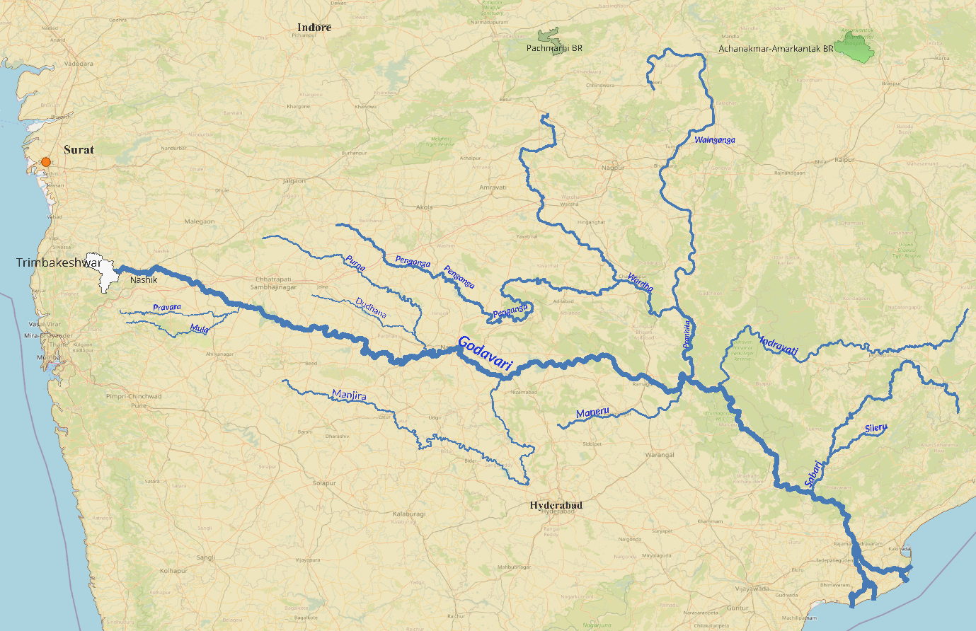
5.2 Tributary Architecture
5.3 Hydraulic Infrastructure
5.4 Waterfalls
Chitrakote Falls on the Indravati River, Bastar, Chhattisgarh: India's widest waterfall (~300 m during monsoon); horseshoe-shaped; called the "Niagara Falls of India." Height: approximately 29-30 m.
5.5 Protected Areas
5.6 River Linking
- Pattiseema Lift Irrigation (2015-16): India's first completed river-linking project. Links Godavari to Krishna via Polavaram Right Bank Canal.
- Godavari-Cauvery Link: Proposed Inchampalli to Nagarjunasagar to Somasila to Grand Anicut; DPR completed 2019; estimated cost Rs. 60,361 crore.
5.7 Critical Facts
- Krishna-Godavari (KG) Basin: Major offshore natural gas/petroleum reserves.
- Highest dam density: The basin has approximately 350+ major/medium dams, the highest in India.
- Singareni coalfields.
6. The Krishna River System
6.1 Course and Geography
The Krishna originates near Jor village, Mahabaleshwar in the Western Ghats, Satara district, Maharashtra, at approximately 1,337 m, just 64 km from the Arabian Sea. It flows east through Maharashtra, Karnataka, Telangana, and Andhra Pradesh for approximately 1,400 km, draining into the Bay of Bengal. Basin area: 2,58,948 sq km (roughly 8 percent of India). The Krishna-Godavari delta is known as the "Rice Granary of India."
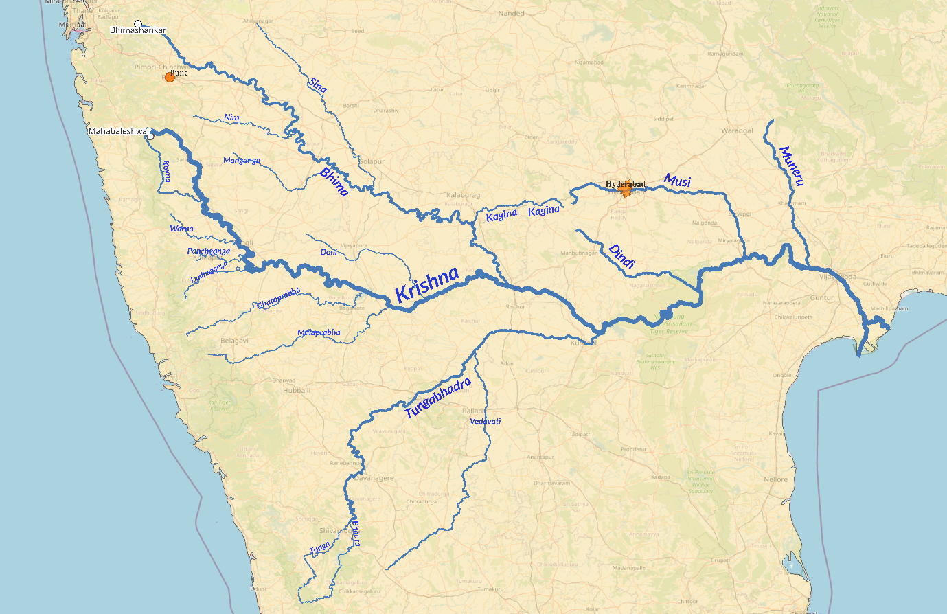
6.2 Tributary Architecture
6.3 Hydraulic Infrastructure
6.4 Waterfalls
- Gokak Falls on the Ghataprabha: 52 m drop; horseshoe-shaped; "Niagara of Karnataka"; first hydroelectric power in Asia generated here (1887).
- Ethipothala Falls (21 m) near Nagarjuna Sagar: crocodile breeding centre below.
6.5 Protected Areas
- Nagarjunasagar-Srisailam Tiger Reserve: India's largest tiger reserve (3,728 sq km); Nallamala Hills; Krishna flows through for 270 km.
- Koyna WLS: Part of UNESCO WHS (Western Ghats, 2012); part of Sahyadri Tiger Reserve.
- Kudremukh NP: Birthplace of the Tunga and Bhadra rivers in the Western Ghats.
6.6 Critical Facts
- Koyna Earthquake (1967): M 6.3; ~200 deaths; world's most famous case of reservoir-induced seismicity; Deccan Plateau previously considered aseismic.
- Raichur Doab: Between Tungabhadra and Krishna.
- Hussain Sagar: Heart-shaped artificial lake linking Hyderabad and Secunderabad, built on a Musi tributary.
7. The Kaveri (Cauvery) River System
7.1 Course and Geography
The Kaveri originates at Talakaveri, Brahmagiri Hills, Kodagu (Coorg) district, Karnataka, at 1,341 m. It flows through Karnataka and Tamil Nadu for approximately 800 km, draining into the Bay of Bengal near Poompuhar. Basin area: 81,155 sq km. Called "Dakshin Ganga" and "Ponni" ("the golden one" in Tamil). Unlike other peninsular rivers, the Kaveri exhibits near-perennial flow because its upper catchment receives Southwest monsoon rainfall while its lower catchment receives Northeast monsoon rainfall.
The river creates iconic islands as it bifurcates and rejoins: Srirangapatna (Tipu Sultan's capital), Shivanasamudra (hydroelectric station), and Srirangam (Sri Ranganathaswamy Temple). The Kaveri Delta (Thanjavur-Tiruvarur region) is the "Granary of South India." Approximately 90-95 percent of the Kaveri's irrigation and power potential is already harnessed.
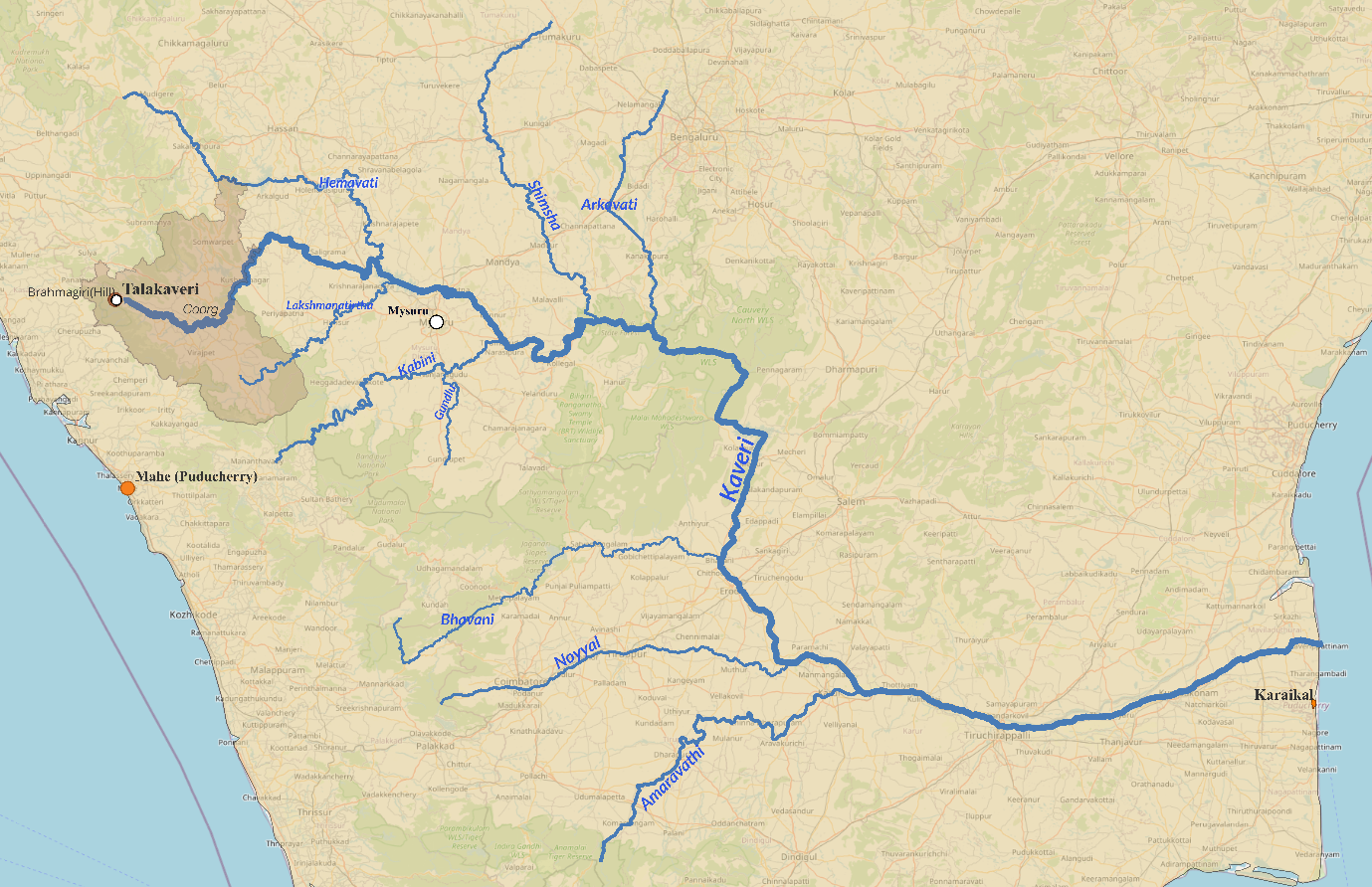
7.2 Tributaries
7.3 Hydraulic Infrastructure
7.4 Waterfalls
- Shivanasamudra Falls (Gaganachukki: 90 m; Bharachukki: 69 m): Asia's first hydroelectric power station established here in 1902 (700 KW); powered Kolar Gold Fields; made Bangalore India's first electrified city (1905).
- Hogenakkal Falls: Called "Niagara of India"; "Smoking Rocks" in Kannada; carbonatite rocks among the oldest in South Asia.
7.5 Protected Areas
7.6 Water Disputes: India's Most Contentious
The Cauvery Water Disputes Tribunal (constituted 1990) delivered its final award in 2007: TN 419 TMC, KA 270 TMC, KL 30 TMC, Puducherry 7 TMC. The Supreme Court Modified Order (16 February 2018) adjusted allocations: Karnataka 284.75 TMC (+14.75), Tamil Nadu 404.25 TMC (-14.75), Kerala 30 TMC, Puducherry 7 TMC, with 10 TMC for environmental protection. The Cauvery Water Management Authority (CWMA) was constituted in June 2018. Karnataka's proposed Mekedatu Dam remains a major flashpoint.
7.7 Critical Facts
- Shivanasamudra (1902): First major commercial hydroelectric station; note Sidrapong, Darjeeling (1898) was India's first, but smaller.
- Grand Anicut: Textbook example of ancient Indian hydraulic engineering; Sir Arthur Cotton modeled his designs on it.
- Srirangapatna: Tipu Sultan's island capital, formed by Kaveri's bifurcation.
8. The Mahanadi River System
8.1 Course and Geography
The Mahanadi originates near Pharsiya village, south of Nagri town, in the Sihawa Hills, Dhamtari district, Chhattisgarh, at 442 m. It flows through Chhattisgarh (~53% of basin) and Odisha (~47%) for approximately 858 km, draining into the Bay of Bengal at False Point near Paradip. Basin area: approximately 1,41,589 sq km. Called the "Sorrow of Odisha" due to devastating historical floods. It is the most active silt-depositing stream in the Indian subcontinent. The Satkosia Gorge (22 km) is where the Mahanadi cuts through the Eastern Ghats. The upper basin forms a distinct saucer-shaped depression known as the "Chhattisgarh Plain."
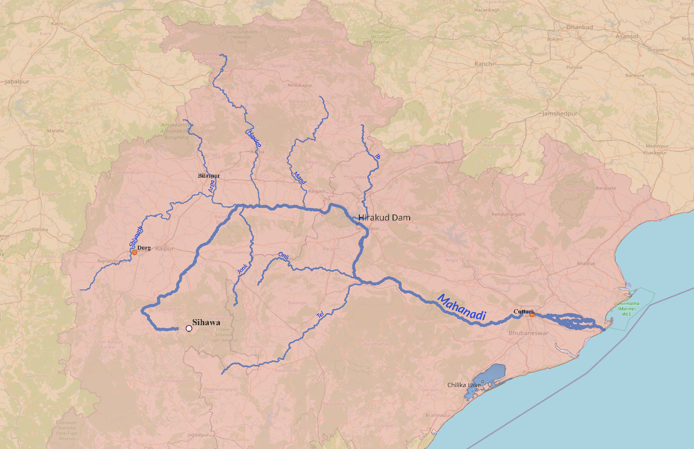
8.2 Tributaries
- Left bank (SHMI mnemonic): Shivnath/Seonath (longest/largest, 345 km; drains ~25% of basin), Hasdeo (333 km; Hasdeo Bango Dam), Mand (241 km), Ib (251 km; Ib Valley coalfield).
- Right bank (JOT mnemonic): Jonk (182 km), Ong (~200 km), Tel (296 km; largest right-bank tributary).
8.3 Hydraulic Infrastructure
8.4 Lakes and Wetlands
- Chilika Lake: South of Mahanadi Delta; largest coastal/brackish water lagoon in India, 2nd largest in world; India's first Ramsar Site (1981); Irrawaddy dolphins; 1 million+ migratory birds in winter.
- Ansupa Lake: Largest freshwater lake in Odisha; oxbow lake of Mahanadi; Ramsar Site (2021).
8.5 Protected Areas
- Bhitarkanika National Park: While geographically adjacent to the broader Mahanadi delta region, this ecosystem is primarily formed by the Brahmani, Baitarani, and Dhamra rivers. It is India's second-largest mangrove ecosystem, houses the largest saltwater crocodile population, and is adjacent to the Gahirmatha Marine Sanctuary (the world's largest nesting beach for Olive Ridley turtles).
8.6 Economic and Navigational Significance
National Waterway 5 (NW-5) comprises a 588 km stretch of the East Coast Canal alongside the Brahmani and Mahanadi delta rivers, essential for transporting coal, fertilizers, and mineral resources from Odisha's mining hinterlands to coastal ports.
Quick-Reference Comparison
Synthesis of the core parameters of all eight river systems for quick revision.
Key Projects Status
Inland Waterways
If you wish to watch Abhijeet Yadav sir cover Indian rivers through maps, click the YouTube link below.
Geography Mapping - Indian RIVERS & Tributaries | UPSC Prelims 2026
Click here to download Practice Maps.
Previous Post