Red Sea
The Red Sea, one of the most saline bodies of water in the world, is an inlet of the Indian Ocean between Africa and Asia.
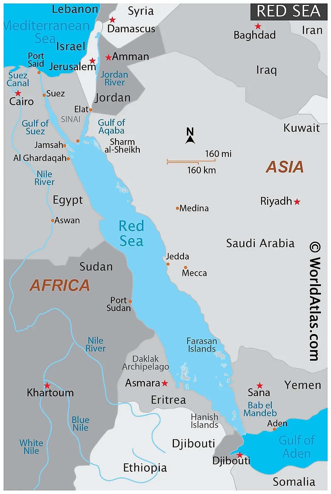
Location/Map of Red Sea
- The elongated and narrow-shaped basin extends between the Mediterranean Sea, to the north-west, and the Indian Ocean, to the south-east.
- At the northern end, it separates into the Gulf of Aqaba and the Gulf of Suez, which is connected to the Mediterranean Sea via the Suez Canal.
- At the southern end, it is connected to the Gulf of Aden, and the outer Indian Ocean, via the Strait of Bab-el-Mandeb.
- It is surrounded by desert or semi-desert areas, with no major freshwater inflow.
Six countries border the Red Sea
- Egypt,
- Saudi Arabia,
- Yemen,
- Sudan,
- Eritrea, and
- Djibouti
Mnemonic - YESS DE
Why Red?
Red Sea doesn’t appear red at all. So how did it get this name and does it ever appear red?
- A popular hypotheses about the origins of the Red Sea's name is that it contains a cyanobacteria called Trichodesmium erythraeum (a red-colored algae), which turns the normally blue-green water a reddish-brown.
- Some other scholars believe it is linked to the way Asiatic languages often use colors to refer to cardinal directions, with “red” referring to “south” just as the Black Sea may be referring to the north.
- If you’re diving in the Red Sea during a seasonal algal bloom, you may see a red tinge in the water
Physical Features
- The Red Sea lies in a fault depression that separates two great blocks of Earth’s crust—Arabia and North Africa.
- The land on either side, inland from the coastal plains, reaches heights of more than 6,560 feet above sea level, with the highest land in the south.
- At its northern end the Red Sea splits into two parts, the Gulf of Suez to the northwest and the Gulf of Aqaba to the northeast.
- The Gulf of Suez is shallow—approximately 180 to 210 feet deep—and it is bordered by a broad coastal plain. The Gulf of Aqaba, on the other hand, is bordered by a narrow plain, and it reaches a depth of 5,500 feet.
Salinity
💡
The Red Sea is one of the saltiest bodies of water in the world, Here are the reasons
- High evaporation and low precipitation;
- No significant rivers or streams drain into the sea, and
- Its southern connection to the Gulf of Aden, an arm of the Indian Ocean, is narrow.
- Its salinity ranges from between ~36 ‰ in the southern part and 41 ‰ in the northern part around the Gulf of Suez, with an average of 40 ‰. (Average salinity for the world's seawater is ~35 ‰ on the Practical Salinity Scale, or PSU; that translates to 3.5% of actual dissolved salts).
Biodiversity:
- The unique habitats of the Red sea support a wide range of marine life, including sea turtles, dugongs, dolphins and many endemic fish species.
- Coral reefs mainly extend along the northern and central coasts, and decrease in abundance towards the southern region, as coastal waters become more turbid.
- The special biodiversity of the area is recognized by the Egyptian government, who set up the Ras Mohammed National Park in 1983. The rules and regulations governing this area protect local marine life, which has become a major draw for diving enthusiasts.
Economic aspects
- Resources - Five major types of mineral resources are found in the Red Sea region: petroleum deposits, evaporite deposits (sediments laid down as a result of evaporation, such as halite, sylvite, gypsum, and dolomite), sulfur, phosphates, and the heavy-metal deposits
- Navigation - Red sea is a part of an important trade route connecting Europe to Asia (Through Suez canal)
- Tourism - The sea is known for its recreational diving sites
Previous Post