
Topic: Important Geophysical phenomena such as earthquakes, Tsunami, Volcanic activity, cyclone etc., geographical features and their location- changes in critical geographical features (including water- bodies and ice-caps) and in flora and fauna and the effects of such changes
Q1. Examine the influence of ocean currents on the atmosphere and economy in different regions across the globe. (10 marks)
Model Structure
Introduction
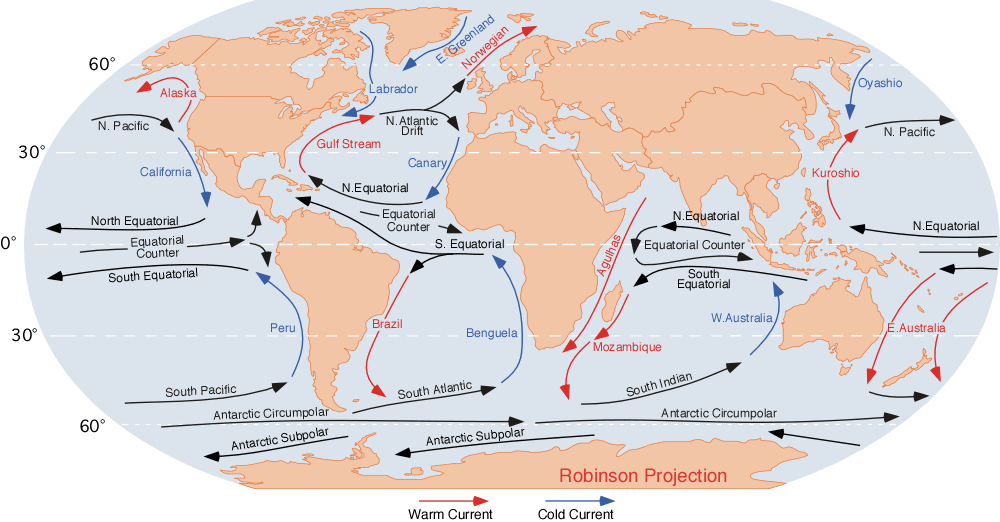
- Ocean current refers to the continuous flow of a huge amount of water in a definite path and direction in the ocean. They can be Hot or Cold, Deep or Surface water currents as per their formation and direction of flow.
Main Body
Effects of ocean currents on the Atmosphere:
- Global ocean conveyor belt: The ocean currents play a critical role in maintaining the global heat budget for the earth system. Ocean circulation transports heat from heat excess to heat deficit regions.
- Local atmospheric weather changes: Ocean currents affect the local climate of a region.
- For example, the North Atlantic Drift increases the temperature off the coasts of the western coast of Europe warm, which is abnormal for high latitudes.
- Similarly, the warm ocean current Kuroshio current in the North Pacific Ocean keeps the ports of the Alaskan coast ice-free in winter.
- El-Nino/La Nina effects: El Nino and La Nina are caused by a build-up of cooler and warmer than normal ocean currents in the tropical Pacific, the area of the Pacific Ocean between the Tropic of Cancer and the Tropic of Capricorn.
- Tropical cyclones: Warm Ocean currents can accumulate warm waters in the tropics, and the accumulation of warm water is the major force behind tropical cyclones.
Effects of ocean currents on the Economy:
- Habitation: Warm Ocean currents can help make certain regions in higher latitudes habitable.
- For example, The Gulf Stream, the Gulf of Mexico along the eastern coast of the US and then to the British Isles.
- Agriculture: Warm Ocean currents lead to the evaporation of warm waters, which generate rainfall on the seashore hence making those areas agriculturally productive.
- Fishing: The mixing of warm and cold currents replenishes the oxygen and therefore promotes the growth of plankton and fishes.
- For example, mixing Oyashio with Kuroshio Currents near the Japanese coast.
- Transportation: Ocean Currents determine the major routes for navigation since ancient times. They increase fuel use efficiency when ships flow in their direction.
Conclusion
- Hence, Ocean currents are a critical part of the earth's stabilisation mechanism. They not only affect the global climate but also intermingle with the human economy around the world.
Diagram of Ocean currents for reference:
Q2. What do you mean by an inversion in temperature? Describe the ideal circumstances for a temperature inversion and also discuss its effect. (10 marks)
Model Structure
Introduction
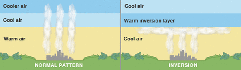
- Temperature inversion occurs when there is a reversal of the normal temperature pattern in the atmosphere, where the temperature increases with height instead of decreasing. In the troposphere, the temperature typically decreases with increasing altitude, known as the normal lapse rate.
Main Body
The ideal circumstances for a temperature inversion are:
- Long winter night: Loss of heat by terrestrial radiation from the ground surface during night exceeds the amount of incoming solar radiation. This results in lower surface temperature.
- Cloudless sky at night leads to more rapid heat loss, while slow movement of air prevents inter-mixing of air.
- Dry air near the ground limits the absorption of the radiated heat, resulting in lower temperatures near the surface.
Temperature inversion has a multidimensional impacts:
- Precipitation: It hampers the vertical ascent of convective clouds, limiting the upward movement of moisture and affecting winter rainfall crucial for Rabi crops.
- It also promotes atmospheric stability in the western regions of continents, leading to arid conditions and the formation of desert ecosystems like the Sahara desert.
- Fog formation: Surface inversion results in the dense morning fog.
- Certain crops, like coffee plantations in the Yemen hills of Arabia, benefit from the fog as it acts as a protective shield against intense solar radiation.
- In urban areas, the inversion layer traps smoke and dust particles, forming smog.
- Increase in air pollution: The slow movement of air during temperature inversions hinders the dispersal of air pollutants, creating toxic air pockets around urban areas, such as the winter pollution in Delhi.
- The high concentration of particulate matter during such conditions contributes to respiratory problems.
- Frost damage: Air drainage, where dense cold air accumulates in valley bottoms with warmer air above, occurs during the night in hills and mountains.
- As a result, apple growers in the mountainous regions of the Himalayas avoid planting their crops on lower slopes to mitigate this risk.
- Telecommunication: Temperature inversion may disturb the radio signals in the region due to refraction from layers above the cold air.
Conclusion
- It is important to have a better understanding of temperature inversion as it impacts the agriculture and transport sectors as well as affects pollution and needs to be studied for better management of issues in those sectors.

Ace the Essay (With Abhijeet Yadav Sir)
A comprehensive course to master the ART AND CRAFT of Essay Writing
Q3. List the various types of seismic waves generated by earthquakes and discuss their importance in gaining insights into the Earth's interior structure. (15 marks)
Model Structure
- Introduction(1): The sudden release of energy from the interiors of the earth leading to the shaking of the crustal slab is called an earthquake. The energy is released in the form of waves from the earthquake's focus, and they propagate through the earth’s differential layers to the epicentre on the surface. OR
- Introduction(2): The rocks in the interior are subjected to high pressure; they tend to store their stress. But whenever there is a fracture in the rocks, the energy is released catastrophically, creating tremors in the crustal slab, which causes an earthquake.
Main Body:
Earthquake waves:
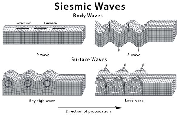
- Primary Waves:
- These are longitudinal waves or compressional waves that follow the pattern of compression and expansion.
- They are faster and travel with a velocity of 25000 Km/hr and are the first to reach the surface.
- They tend to change the shape and volume of the rocks through which they propagate, but they have less impact on the surface.
- They propagate in all mediums and the shadow zone.
- Secondary waves:
- They are low-velocity Sinusoidal waves, also called Distrotional waves.
- They tend to impact the shape and not the volume of the rocks.
- They have slower velocities, but the maximum destruction is due to S-Waves.
- They do not propagate in liquids and the shadow zone.
- Rayleigh waves:
- These are the waves with Sea-Swell motion.
- These waves tend to shift the ground vertically upwards or downwards.
- Love-waves:
- It follows the motion called the Whipping motion.
- It shifts the ground horizontally and creates a rift valley like the San Andreas fault lines of the USA.
The discovery of these waves has benefited the study of geomorphology and interiors of the earth. They are significant to understand the interiors of the earth due to the following factors:
- Composition: The speed of the waves varies with density, thus, by observing their propagation speed, we can identify the density and, thus, the composition of rocks beneath, which could help in mineral exploration.
- Identification of discontinuities: The waves helped to discover the existence of Moho’s discontinuity and Gutenberg's discontinuity.
- Density: The study of waves led to the establishment of the fact that mantle is denser than crust and crust is semi-molten material.
- This led to theories like Hess's theory, Continental drift theory and also explained Volcanism.
- Earthquake determination: As S-waves are faster and less destructive, we can use the window period between S and P waves to alert the public of earthquakes.
Conclusion:
- The study of waves is important in contemporary times, and earthquakes occur even to anthropogenic activities, as observed in Latur, Maharashtra. They act as a window to the interiors of the earth and also help in hydrology that studies groundwater and its water table.
Q4. Write a note on the distribution of volcanoes across the world. Why does the distribution of volcanoes coincide with that of earthquakes? (15 marks)
Model Structure
Introduction:
- Volcanism is the process of eruption of molten material or magma into the crust, which is poured out on its surface. Volcanic activity is closely associated with plate boundaries, crustal disturbances etc.
- Volcanoes around the world are located in a clearly-defined pattern. It is closely related to regions that have been intensely associated with plate tectonic activities.
Main Body:
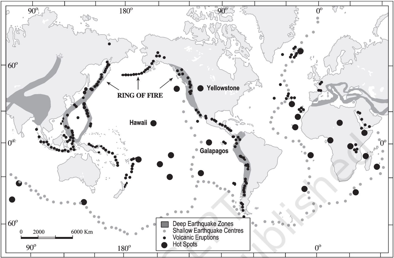
Distribution of volcanoes across the world:
- Volcanoes at Convergent Plate boundary – In such regions, one plate subducts under another plate.
- Circum-Pacific region (“Pacific Ring of Fire”). On the Western side of the Pacific Ocean, this chain extends from the Aleutian Islands, Japan, the Philippines, the southern Pacific Islands of Solomon and New Zealand and on the Eastern side of the Pacific Ocean, it extends from Alaska, Mexico to Central America, and the Andes.
- The Atlantic coast has few active volcanoes, but many are dormant or extinct, e.g. St. Helena, Canary Islands etc., but volcanoes in Iceland and Azores are active.
- In the Mediterranean region, volcanoes are mainly associated with the Alpine folds, e.g. Mt. Etna, Mt. Stromboli etc.
- Volcanoes at Divergent Plate boundary – When two plates are moving away from each other, along these boundaries, magma rises from deep within the Earth and erupts to form a new crust on the lithosphere.
- Most of the active divergent plate boundary is present at mid-oceanic ridges, where constant sea-floor spreading and formation of new plate boundaries can be seen.
- Some volcanoes are also located in Rift valley in Africa, such as Mt. Kilimanjaro, Mt. Kenya, and Mt. Cameroon.
- Volcanoes due to hot spot activities – This occurs at the interior parts of the lithospheric plates rather than plate boundaries, e.g. Reunion hotspot in the Indian Ocean, Hawaiian hotspot in the Pacific Ocean and Yellowstone hotspot in North America.
Coincidence of distribution of volcanoes and earthquakes:
- Both phenomena are associated with tectonic activities, and energy released from one phenomenon gives rise to another.
- Earthquakes are found along all types of plate margins (constructive, destructive and transform). However, Volcanoes occur at constructive and destructive plate margins only.
Reason for coincidence:
- Subduction zone: In these subduction zones, overlapping plates cause slip between them and rupture within plates, leading to earthquakes.
- Also, the consumption of oceanic plates in the mantle gives rise to volcanoes.
- Movement of magma: Compression of plates forces the magma beneath them to move, but this movement is difficult for a newly compressed crust.
- This causes the magma to pool in magma chambers beneath the surface and between the converging plates.
- With the movement of plates, this magma is forced to move in or out of these chambers and thus causing Volcano-tectonic earthquakes.
- Injection of magma and cracking of rocks: Injection of magma into surrounding rocks causes them to break, and every time the rock cracks, it causes small earthquakes.
- Diverging plates: At diverging plate boundaries, along with the volcanic activity due to the rise of magma, the creation of new crust pushes other crust.
- Cracking of the crust and formation of faults causes earthquakes in these regions.
Conclusion:
- Thus, plate tectonic activities are important in volcanic activities and earthquake events. The concentration of volcanic activities and earthquakes in a particular belt affects the life of people in these regions significantly.
Q5. Though the Bay of Bengal experiences more tropical cyclones as compared to Arabian Sea, recently the Arabian Sea has also started experiencing more cyclones. Enumerate the reasons and also how to lessen the impact. (10 marks)
Model Structure
Introduction
- Tropical Cyclone is a rotating low pressure weather system originating on seas and oceans in tropical areas due to conducive temperature, and makes landfall in coastal areas causing stormy weather and heavy rainfall.
Main Body
Arabian Sea is less prone to cyclones when compared to Bay of Bengal due to relatively colder sea surface temperature because it is an open water body and not continental. But there are many reasons for the increased frequency of cyclones in the Arabian Sea like-
- With westerlies becoming more pronounced, rightward movement of cyclones has become frequent which makes western coastline more vulnerable to cyclones.
- Most of the peninsular rivers are east flowing thus the Arabian Sea receives less fresh and cool water. And higher SST promotes cyclone formation.
- Positive Indian Ocean Dipole and warmer than normal SST in the Arabian Sea promotes cyclone formation in Arabian sea.
- As per IPCC report, SST of Arabian Sea has steadily increased in the last 40 years in the range of 1.2-1.4 degree celsius.
- Highly populated gulf region and South Asain countries means more carbon emissions and global warming in this particular region.
- Change in direction and speed of the winds is called wind shear which is weakening in recent times due to increase in carbon in the atmosphere. The result is that stronger wind shear in the Arabian Sea is now weakening which fosters the formation of cyclones.
Thus there are many reasons and there is an urgent need to mitigate the cause and impact of such cyclones. This can be understood by steps in the disaster management cycle. Some of these steps include-
- Early warning systems like weather stations and their use of supercomputers, ocean buoys, doppler radars etc.
- Any warning needs to be disseminated and for that communication systems must be in place.
- Embankments and similar structures must be built to protect life of humans and livestock, habitations, crops etc.
- Coastal zone management is another important aspect which is aimed at protection of local communities.
- Projects like National Cyclone Risk Mitigation Project which aims to strengthen the structural and non-structural efforts and reduce vulnerability of the coastal areas.
- Community Based Disaster Management which aims at capacity building of communities to reduce their vulnerability.
Conclusion
- Any disaster brings loss of life and property with a lot of time taken to normalize things. Thus it is important to implement the measures in place for disaster risk mitigation.

Mains Focus Group - GS Advance + Write UnLimited (for Mains 2027)
LIVE Answer Writing Sessions